"Hail to thee, O Nile! Who manifests thyself over this land, and comes to give life to Egypt!" – Hymn to the Nile.
Geography is destiny. Nowhere is this truer than in Egypt. The peculiar shape and flow of the Nile River didn't just define the borders; it defined the religion, the political structure, and the very concept of duality that permeated Ancient Egyptian thought.
The Longest Highway in Antiquity
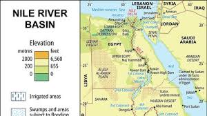
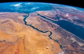
Stretching over 6,600 kilometers, the Nile was the ancient world's longest river. Uniquely, it flows from South to North, originating in the highlands of East Africa and emptying into the Mediterranean Sea.
- Unification: This direction allowed the river to act as a natural zipper, binding the diverse cultures of the south and north into a single nation-state.
- Navigation: The current flows north, but the prevailing wind blows south. This allowed for effortless travel in both directions—drifting downstream with the current and sailing upstream with the wind. This ease of transport made Egypt the first great unified kingdom.
The Two Lands (Tawy)
The Egyptians didn't call their country "Egypt" (a Greek term); they called it Tawy, "The Two Lands." This referred to the distinct geographical zones created by the river. To the modern mind, the names seem reversed because they follow the flow of the river, not the compass.
Upper Egypt (The South)
This is the Nile Valley, extending from the First Cataract at Aswan down to Memphis (near Cairo).
- Landscape: A narrow strip of green cultivated land squeezed between towering limestone cliffs and harsh desert.
- Symbol: The Lotus (Water Lily).
- Crown: The White Crown (Hedjet).
Lower Egypt (The North)
This is the Nile Delta, where the river fans out into the Mediterranean Sea.
- Landscape: A wide, flat, marshy plain crisscrossed by river branches (originally seven, now two). It was the breadbasket of the ancient world.
- Symbol: The Papyrus plant.
- Crown: The Red Crown (Deshret).